High severity and high frequency crash intersections were identified using the Equivalent Property Damage Only (EPDO) method, one of the safety network screening performance measures included in the Highway Safety Manual. The EPDO analysis methodology places greater emphasis on crash severity compared to other common methods that only consider crash frequency, providing insight into locations that have low total crash frequency but have experienced one or more fatal or suspected serious injury crashes. The EPDO method assigns societal costs to each crash by severity level to develop an equivalent property-damage only value (i.e., each crash is scored based on their relative magnitude to a property damage only (PDO) crash). An EPDO analysis does not set thresholds for what score is good versus bad, rather its methodology establishes a way to compare locations. The final component of the Safety Evaluation is the roadway characteristic-based assessment which looks at the physical properties of the roadways in Teton County.
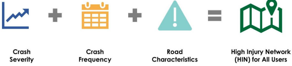
The High Injury Network (HIN) for Teton County identifies areas where investments in transportation safety could have the greatest impact in reducing fatal and serious injury crashes. The HIN combines the results of the high frequency and severity crash analysis and the roadway characteristic assessment. To create the HIN, these analysis layers were overlaid onto a single map.
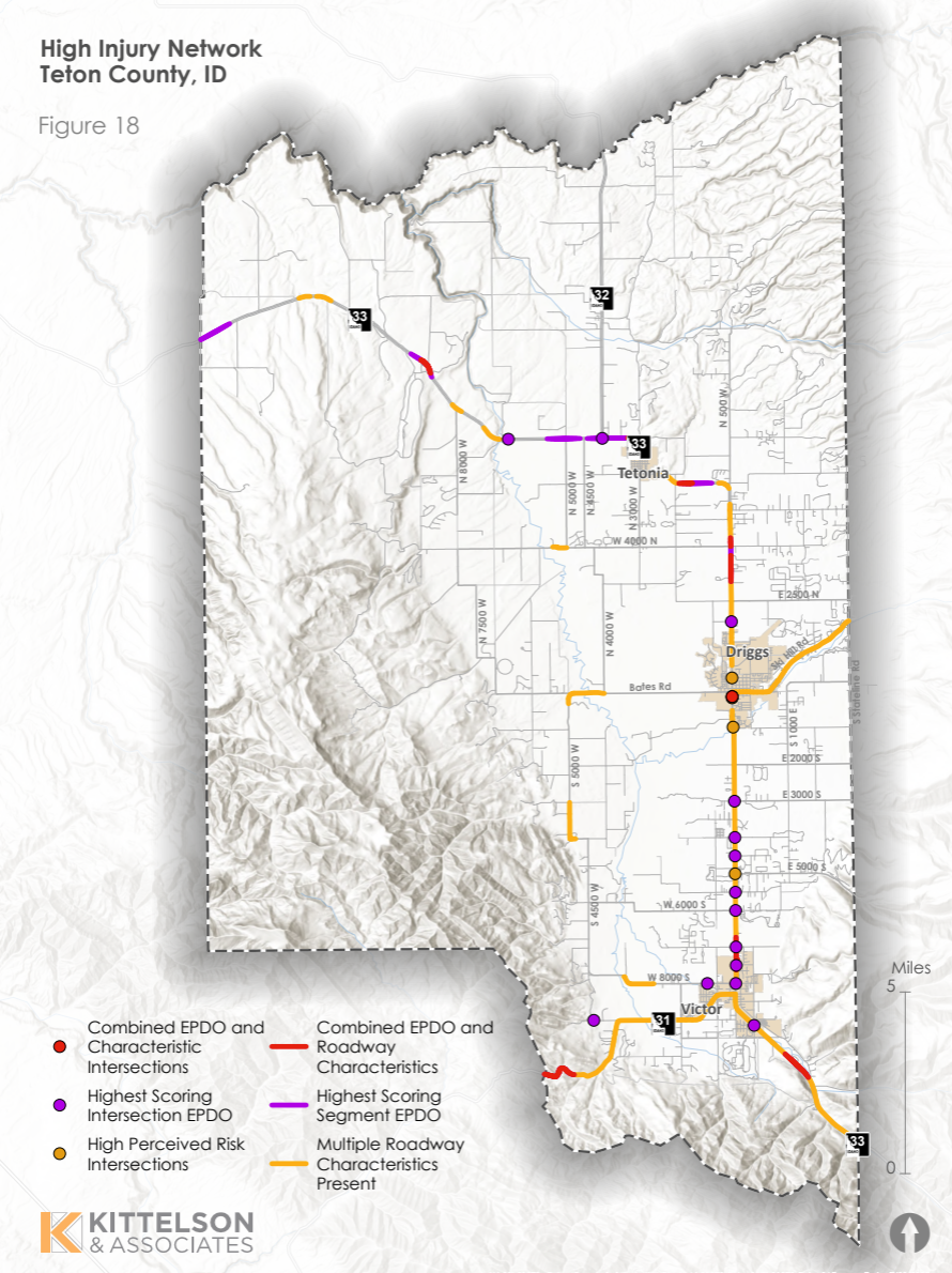
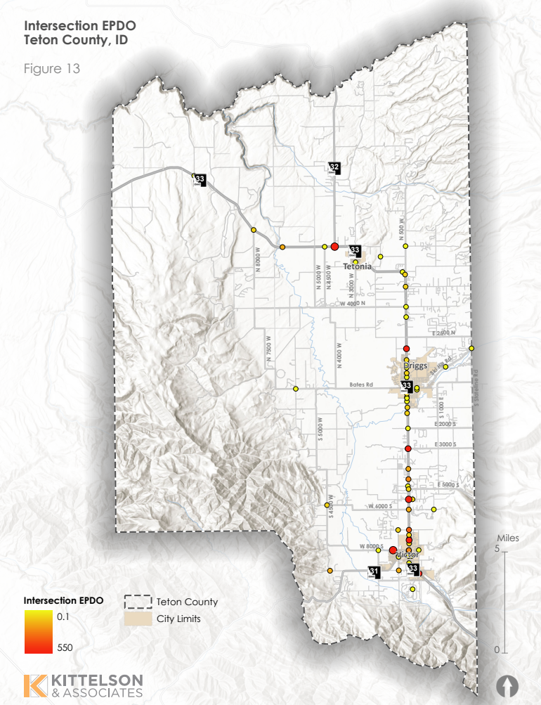
Of the 73 intersections in Teton County with EPDO values greater than zero, 34 (approximately 47%) intersections are located within the city limits of either Driggs, Tetonia, or Victor. Of the 15 intersections with at least one suspected minor injury crash, 4 (approximately 27%) are located within city limits. 13 of the 15 intersections with at least one suspected minor injury crach (approximately 87%) are located along Highway 33 (ID 33). The map below shows the EPDO value for all intersections with a score greater than zero.
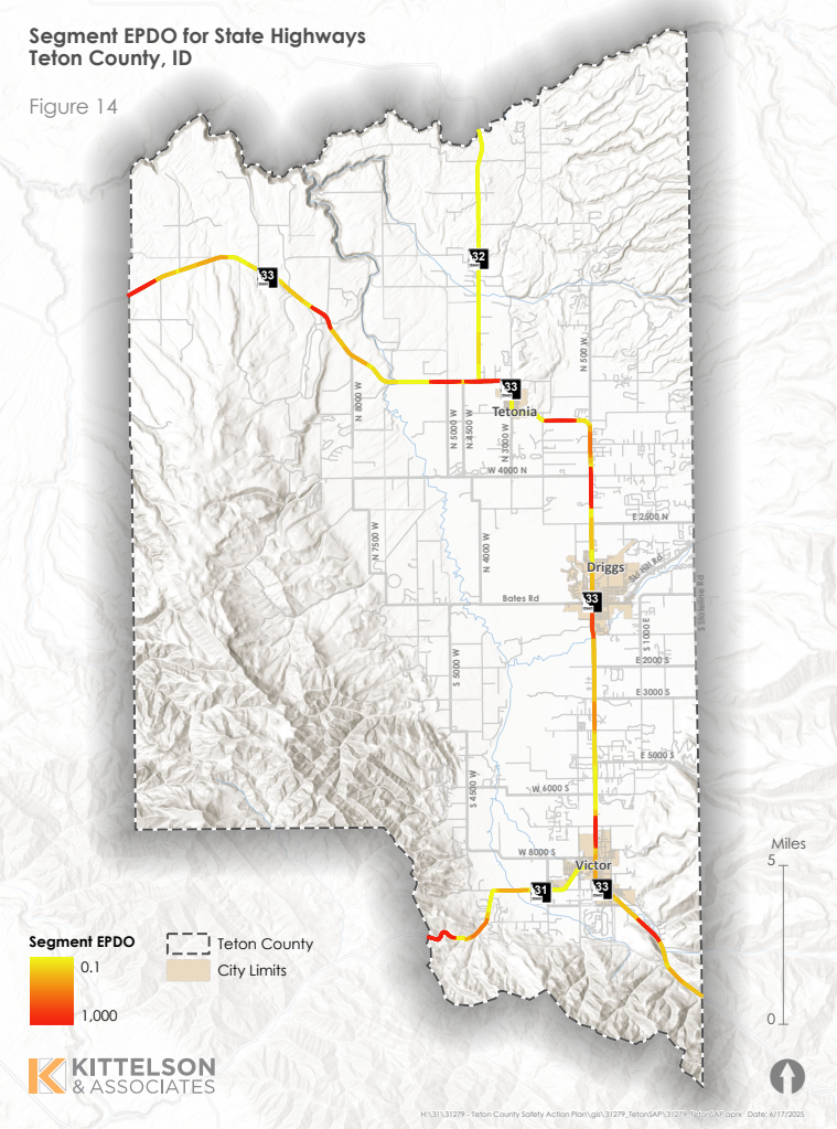
Because more fataI and serious injury crashes occurred along segments than within intersections, segment EPDO values reached significantly higher values when compared with intersection EPDO values. For this reason, the EPDO value used as a threshold is higher for segments than for intersections. The EPDO value for all State highway segments is shown in the map below.
Between June 6th and July 11th we conducted four in-person outreach events and received 102 responses to our online survey. Results of the public outreach revealed repeated themes and locations of concern. As with the HIN, these centered around SH 33. The most significant themes from our qualitative analysis are below:
- Turn lanes on SH 33 between Driggs and Victor are desired
- Lack of law enforcement is perceived as contributing to unsafe roadways
- Multimodal facilities connecting Tetonia to Driggs are desired
- Multimodal facilities for crossing SH 33 are desired at multiple locations, especially in the Fox Creek area
- SH 33 between 2500 N and 4000 N is unsafe and congested
- The crosswalk at Creekside Meadows/Trail Creek is unsafe
- More public transit options are desired, within Teton County and to Teton County, Wyoming
- Crosswalks in Driggs were identified as poorly marked and poorly respected by drivers
Following the Study Advisory Team Kick-Off meeting in April, we developed a public engagement plan and launched the first phase of public outreach for our Safety Action Plan. This consisted of a public Townhall Meeting, concurrent project website, and online survey. We also conducted intercept outreach at three existing community events, in order to lower the barrier to participation by reaching people where they were. Materials in English and Spanish were posted to promote the events and distributed in-person to promote the website and survey.
Our first in-person public outreach event was held on Friday June 6 in downtown Driggs at the GeoCenter. Materials and staff were available from 4-7 pm, both indoors and outside in the plaza. Snacks and beverages were provided. A total of 21 people visited the Townhall event, providing a cumulative 79 comments on our poster boards.
Posters contained questions mirroring those on the online survey, which launched the same day. These questions were separated into categories based on vehicular and non-vehicular travel. People were also asked to identify locations of concern, both for vehicles and non-vehicle travel. Each of the questions is listed below, followed by a synthesis of the major topics contained in comments received.
In your daily travels, do you walk, bike, use transit, or any other mode besides personal vehicle?
If yes, what? Why?
If no, why not?
Is there anywhere you would bike or walk if it were safer to do so?
What is your biggest concern getting around Teton County without a personal vehicle?
Summary:
- Support for 35 mph speed limit on Ski Hill Rd
- Need for enforcement of speed limit on Ski Hill Rd
- Calls for flashing lights at pedestrian crossings
- Calls for better striping/marking of pedestrian and bicycle facilities
- Calls for maintenance of striping/marking, as well as surfaces in pedestrian and bicycle facilities
- Need for bicycle facilities north of Driggs, connecting to Tetonia and Hatches Corner
What is your biggest safety concern relating to roadways in Teton County?
What is your biggest operational concern relating to roadways in Teton County?
What is your biggest concern getting around Teton County in a personal vehicle?
Summary:
- Concern about speeding in general
- Need for turn lanes on SH 33
- Need for patrol/enforcement of speed limits
We also received three comments regarding the need for flashing lights for wildlife crossings. A complete list of the comments received can be found in the appendix.
Our project webpage also went live on Friday June 6th, providing background information on the project, including a summary of the SS4A grant program, project budget, team members and timeline. The website also provided existing conditions data including crash statistics for vehicles and wildlife, and hosted our public outreach survey. All of the online content was available to be translated to a variety of languages via a Google Translate widget embedded on the site.
The online survey was live from Friday June 6th until Friday July 11th, approximately five weeks. The survey questions mirrored the questions asked on our in-person townhall materials, and could be accessed with a desktop browser or mobile app.
Although Teton County does not have any Areas of Persistent Poverty according to the SS4A definition, the Study Advisory Team identified three historically underserved groups which were targeted for public outreach. These were Hispanic/Latino community members, seniors, and those living with a disability. To capture responses from these groups, the online survey was promoted through Teton Adaptive Sports, Seniors West of the Tetons, the Food Pantry, the Community Resource Center, Valley of the Tetons Library, and large employers including MD Nursery and Valley Lumber. QR codes were also displayed in START buses and at various bulletin boards.
During the five week period, also did in-person outreach at three community events which included Music On Main, the Driggs Farmers Market, and the Seniors West of the Tetons annual picnic.
Staff helped people fill out the survey online, participated in conversations, and answered questions about the project. Attendees at the in-person and intercept events wrote comments on sticky notes and followed our QR code to the website.
The survey consisted of demographic background questions, short answer questions about vehicular and non-vehicular travel, and a section asking respondents to identify unsafe locations on a map.
We were interested in finding out the major safety concerns in the community, related to vehicular travel as well as non-vehicular travel such as walking or biking. We also wanted to hear about places that people have experienced safety or operational issues, which may not be captured by traditional traffic data sets. By gathering qualitative data from the community, information that supports conventional crash statistics or reveals issues that are missed in conventional data can create a more equitable and representative strategy for improving safety.
Before the survey closed, we received 102 responses. 80% of respondents were residents of either Victor or Driggs (zip codes 83455 and 83422). 74% of respondents worked and lived within Teton County, with 14% commuting to or from counties to the west and 10% commuting to Teton County, Wyoming. The largest age group of respondents was 41-50 years old, with 35% of respondents belonging to this category. Those between 31 and 40 years of age represented another 20%. 19% of respondents were between 61 and 70 years old.
To analyze the results, comments for each question were coded based on their subject, topic, or theme, and then categorized. This qualitative analysis groups responses based on an understanding of the references to specific locations and familiar concerns within the community. Grouping comments according to subject does not capture every concern recorded by respondents, however, a complete list of comments received can be found in the Appendix. The most common topic contained in the 102 responses was safety concerns on SH 33. Within this category, comments addressed pedestrian and bicycle crossings, turning movements for vehicles, speeding, and many identified specific unsafe locations. Specific missing connections for sidewalks and pathways were identified, as well as unsafe intersections on and off of SH 33. A summary list of cross-cutting themes is below:
- Turn lanes on SH 33 between Driggs and Victor are desired
- Lack of law enforcement is perceived as contributing to unsafe roadways
- Multimodal facilities connecting Tetonia to Driggs are desired
- Multimodal facilities for crossing SH 33 are desired at multiple locations, especially in the Fox Creek area
- SH 33 between 2500 N and 4000 N is unsafe and congested
- The crosswalk at Creekside Meadows/Trail Creek is unsafe
- More public transit options are desired, within Teton County and to Teton County, Wyoming
- Crosswalks in Driggs were identified as poorly marked and poorly respected by drivers
Results of our qualitative analysis identify general concerns for each question topic. Because respondents were able to fill in a blank short-answer field, some of the responses do not specifically answer the question or contain ancillary topics. These were grouped by theme and we attempted to capture all relevant information with broad categories. Results of our analysis are summarized below for each survey question.
In your daily travels, do you walk, bike, use transit, or any other mode besides personal vehicle?


In the charts above, we see that most non-vehicular respondents are traveling by bike and that they prefer biking for exercise. However, a significant percentage, 21%, prefer an alternative to cars for convenience, and another 10% reported that biking or walking was preferable to driving in traffic.

For the question, “Is there anywhere you would bike or walk if it were safer to do so,” respondents entered a variety of topics and locations, and some reported ‘no.’ Some specific places were mentioned multiple times, and some by many of the respondents. The most common location reported was SH 33 north of Driggs. The figure above shows the most common repeated locations by percentage of comments. The titles of these categories are paraphrased from the comments and represent a summary of similar comments.
Our final question captured people’s concerns from a broad standpoint so that our survey responses would reflect the most genuine opinions possible. To achieve this, we used a generalized question: “What is your biggest concern getting around without a personal vehicle?”

‘Biggest Concern’ response trends followed those from the other survey questions. Crossing SH 33 on foot or on a bike is a major concern of the community. The need for bike facilities, pedestrian facilities, as well as concern over interactions with drivers, and being hit by a vehicle, reflect a desire for safe, accessible routes for non-vehicular travelers. These concerns identify interaction between bicyclists/pedestrians and vehicles on shared facilities as an issue to be resolved. This can be achieved by increasing separation between users with striping, bollards, etc., or by creating completely separated pathways. 11% of respondents felt that getting around the county without a personal vehicle was just not possible, and a few commentors mentioned that this is especially true in winter. Of note are the 13% of comments which desire more options for public transit. These included links to Jackson/Teton County, WY, as well as within Teton County, Idaho.
When we asked people about vehicular safety, the most common topic mentioned was turning on or off SH 33. Many comments identified the section of SH 33 between Driggs and Victor, and mentioned left turns with related safety problems such as being rear-ended, people passing on the right shoulder while cars were waiting to turn left, or the danger of entering the highway from side streets.
Other topics contained in multiple comments include the danger of cars not respecting or seeing crosswalks, high speeds, and pedestrian/car interactions in general. Fewer commentors mentioned lack of law enforcement, general traffic, wildlife, potholes, and sidewalk connectivity/condition. Two comments identified Victor back-in parking as their main safety concern. The figure below details the percentage of comments which addressed each topic.

In addition to safety concerns, we asked people about their operational concerns, which are delays, congestion, roadway conditions, line-of-sight, and other facility related items. Responses to this question followed similar topics, with many comments containing concerns about driver behavior and SH 33 safety. Comments which more specifically addressed operational concerns were focused on potholes and road condition, which comprised 21% of responses. Traffic congestion in Victor and Driggs associated with the stoplights was the second most common topic, with 16% of responses. Multiple responses identified large snow piles in Driggs that blocked line of sight. Although it is not strictly an operational issue, this question prompted 10% of responders to comment on aggressive and distracted driving.

In the second part of the survey, we asked people to identify locations on a map where they had felt or witnessed something unsafe, either related to vehicle travel or multimodal travel. Each map point was accompanied by the question, “why did you chose that location.”
Responses revealed some important specific locations where improvements in sight-distance or road conditions are needed. These can be found listed in the Appendix. Themes repeated in this comment section included crossing SH 33, especially the marked crosswalk at Creekside Meadows Avenue on SH 33. Three commentors mentioned this location and six other comments addressed pedestrian crossings in Driggs. These were the most commonly repeated locations. Other top locations included the stretch from 2500 N to 4000 N on SH 33, the intersection 5500 S and SH 33, Bates Road, and the MD Nursery entrance and exit on SH 33.
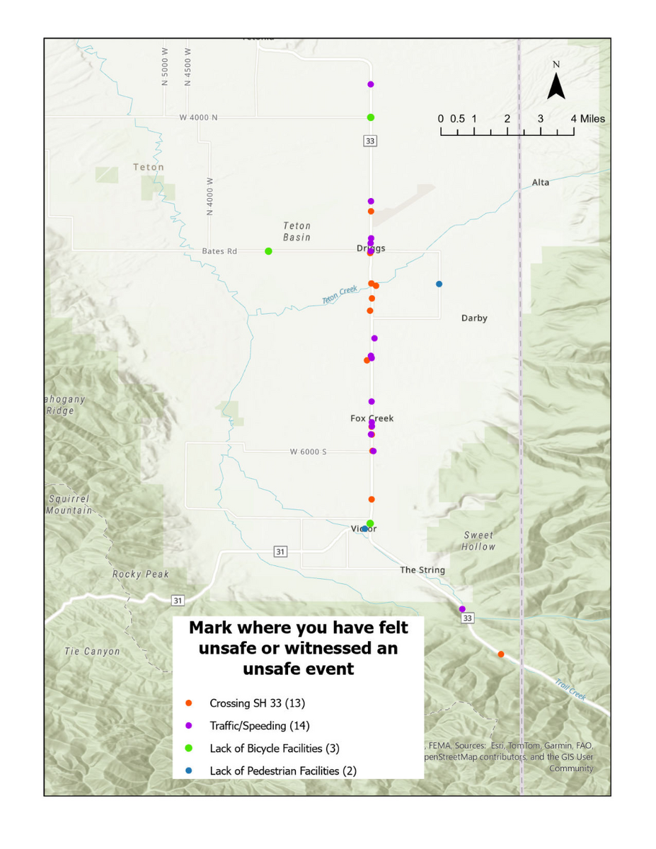
Tabulated another way, each comment and location was coded with one of four categories of concerns: ‘Crossing SH 33,” “Traffic/Speeding,” “Lack of Bicycle Facilities,” and “Lack of Pedestrian Facilities.” The map below shows the concentration and number of responses for each category.

The map shows that crossing SH 33 is a concern at the Creekside Meadows crosswalk, and at MD Nursery, with orange dots clustered in these areas. Another location of note is north of Victor at Larkspur, near Valley Lumber, where there are a number of businesses and multifamily housing developments. Because the bike path is on the west side of the highway, accessing homes or employment centers on the east side can be dangerous for bicycles and pedestrians.
Comments regarding traffic and speeding, which also include responses that mentioned turning onto or off the highway and passing safety, are clustered in the vicinity of Fox Creek on SH 33, as well as the controlled intersection at Little Ave and SH 33. Existing conditions data shows this segment and intersection as heavily travelled.
Unsafe incidents due to lack of bicycle facilities were identified on Bates Road, in the town of Victor on SH 33, and at 4000 N and SH 33. Similar comments for pedestrian related incidents occurred on E 1000 S and in Downtown Victor. The locations identified reflect the need for safety improvements at segments and intersections predominantly along SH 33.
By the second week of July, we received over 100 online survey responses, attended three community events, and conducted a dedicated Townhall meeting in order to promote the project and gather feedback on roadway safety concerns. Combined with the online survey, comments gathered at the in-person events including the Townhall revealed consistent themes in systemic concerns as well as unsafe locations. Some comments identified specific smaller issues contributing to safety concerns around the County, high-lighting the utility of broad community feedback in providing information to help maintain the transportation system. These are listed in the Appendix. Takeaways from the first round of public input are listed below.
State Highway 33 is the focal point of safety and operational concerns
Safety concerns center on entering and exiting SH 33 for vehicles, and crossing the highway at various locations for pedestrians and bicycles
There is a desire for more separated multimodal connections within the cities and between them, especially from Driggs to Tetonia
There is community desire for more public transit options as well as increased law enforcement